

More than 160 residences in Tremont could be inaccessible in flooding event

APR 24, 2024
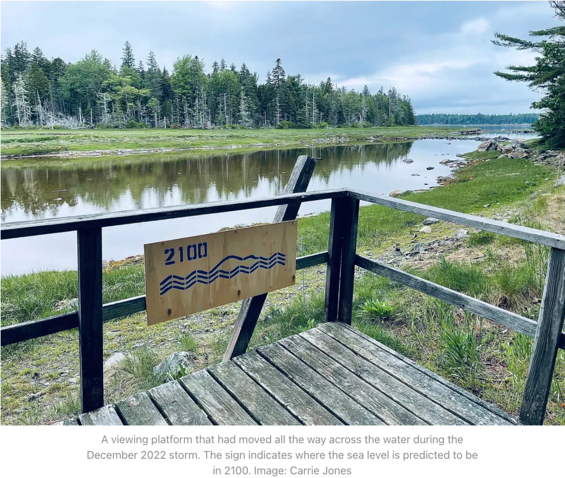
TREMONT—A road to a national park campground is washed away in many places, covered in rocks in others. A dock house is swept into the sea. Near the Tremont Consolidated School, a bridge waits to be overwhelmed by tidal waters. Over on the town’s wharf, electrical outlets are easily submerged in high-flood times.
The forces of nature and of storms like the ones this past winter are huge and mighty. Ways of life, working waterfronts, and residences are threatened by approaching tides. The town of Tremont knows this firsthand, as do others on Mount Desert Island.
Tremont has been through a lot this winter, and if voters agree at its town meeting in May, the town might have a plan to hopefully become more resilient to weather events like the past winter’s storms. It adopted a climate resolution in 2021. And it’s been previously declared one of Maine’s twenty most climate-vulnerable towns.
How vulnerable?
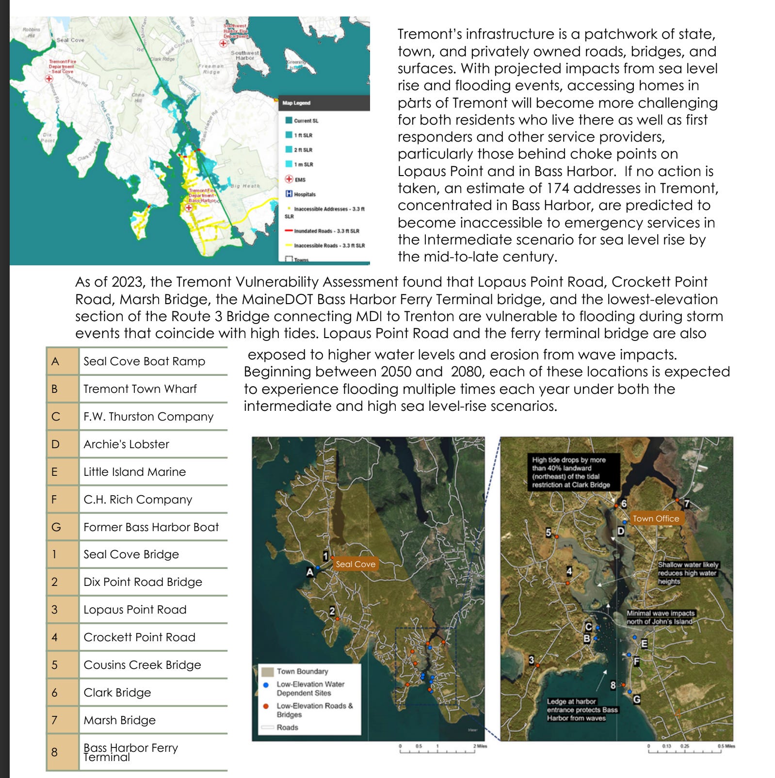
It’s estimated that the town of approximately 1,500 people could have more than 160 residences inaccessible in a flooding emergency. Most of those residences are in Bass Harbor. It’s school is in a low spot by a bridge. It’s working waterfront area is vulnerable as well. It’s aquifer, which supplies people fresh drinking water, is vulnerable to sea water infiltration.
Tremont’s Emergency Management Director and Fire Chief Keith Higgins stressed “that there is no immediate danger to access or evacuate residents from any location in Tremont. We communicate directly with the fine folks at HCEMA (Hancock County Emergency Management Agency) and hope to be proactively preparing for the far extended future.”
He also spoke of the residents own resiliency when it comes to emergencies, life choices, and needs. “When an individual chooses to live in isolated, picturesque and hard working coastal community like ours they anticipate fewer services and liberties,” he said.
Tremont is not the only town on the coast and it wasn’t the only one impacted by king tides or massive storms with high tides and flooding this past year. Multiple areas are vulnerable, and many think that they will be stronger working together.
Could a regional approach be beneficial to local towns as they look toward how vulnerable they are to sea level rise?
A Climate to Thrive’s Executive Director (ACTT) Johannah Blackman believes so. ACTT works closely with multiple Mount Desert Island towns. Its mission, according to its website is “to transition Mount Desert Island off fossil fuels, rapidly reducing greenhouse gas emissions through a combination of locally sited and owned clean energy generation, energy efficiency, and electrification.”
One meeting. One grant. One workshop. One assessment. Step by step, the organization has been working on that mission. Others, such as the Musson Group and Bar Harbor Planning Director Michele Gagnon have advocated for this approach when it comes to dealing with affordable homes. Others, such as multiple chambers of commerce and town planners and economic directors throughout the region have advocated this approach when it comes to economic development. Currently, the school system is looking toward reorganization. Fire and police departments have mutual aid agreements. Collaborations have occurred and are occurring in multiple ways. For many who are worried about rising tides and climate impacts, banning together makes sense.
On Tuesday morning, April 23, Blackman began a discussion with the League of Towns about vulnerability assessments and impacts due to sea level rise. Several towns, she said, are completing these assessments with the Gulf of Maine Research Institute (GMRI). However, she said, “it became clear that more of a regional approach might be beneficial to the towns.”
Already, Tremont has completed an assessment with GMRI and A Climate to Thrive.
Tremont’s Community Resilience Plan was completed in March. The Tremont Select Board unanimously recommended it be adopted at town meeting May 14 .
The plan contains multiple strategies to address different areas of impact such as infrastructure and transportation, working waterfront, economic resilience, critical community services, healthy community, and natural solutions.
The towns of Southwest Harbor and Mount Desert have funding to also do assessments. Bar Harbor has a plan and task force on the climate emergency. The Community Resilience Partnership Program is funding a GMRI plan and multi-town project on the Blue Hill Peninsula and also supporting a collaboration between Mount Desert and Tremont. GMRI, according to its website “is a non-profit marine science center and research institute located in Portland, Maine.”
But, Blackman and GMRI representatives stressed that for many of the issues of resiliency, the communities of Hancock County and especially those on the coast would do well to work together rather than as singular towns. The areas are a patchwork of needs and ownership. There are state roads, local roads, and Acadia National Park (federal) roads. There are hospitals and businesses and residences and nonprofits all involved in communities here.
Because of its assessment and planning, Tremont is recognizing where people are being impacted by power outages and how that combines with flooding. A resilience plan or hub could be funded by federal grants and have solar generation, battery storage, a small diesel generator and also have a peer-to-peer network to check on and care for the most vulnerable populations if power outages and flooding happens.
“It is definitely very helpful when you come to applying for grants,” Tremont Town Manager Jesse Dunbar said of the plan. Having a plan elevates the town’s applications for outside funding for climate resiliency needs.
And there are needs for many island towns, many agreed, big needs.

“We should be having this conversation for all of MDI,” Deputy Superintendent of Acadia National Park and St Croix International Historic Site Brandon Bies said. A road that goes through park land and to Seawall Campground, but is maintained and controlled by the state has been washed out multiple times because of this winter’s storms. It is still impassable.
But that’s not the only place that’s vulnerable.
For Tremont, even bridges built by the state within the last twenty years are in jeopardy.
“They were not constructed with sea-level rise in mind,” Dunbar said.
There are also issues on the route to Tremont and other island towns.
“The causeway coming onto the island will be cut off because of high tides,” Blackman said projections show. “That’s going to become a huge issue.”


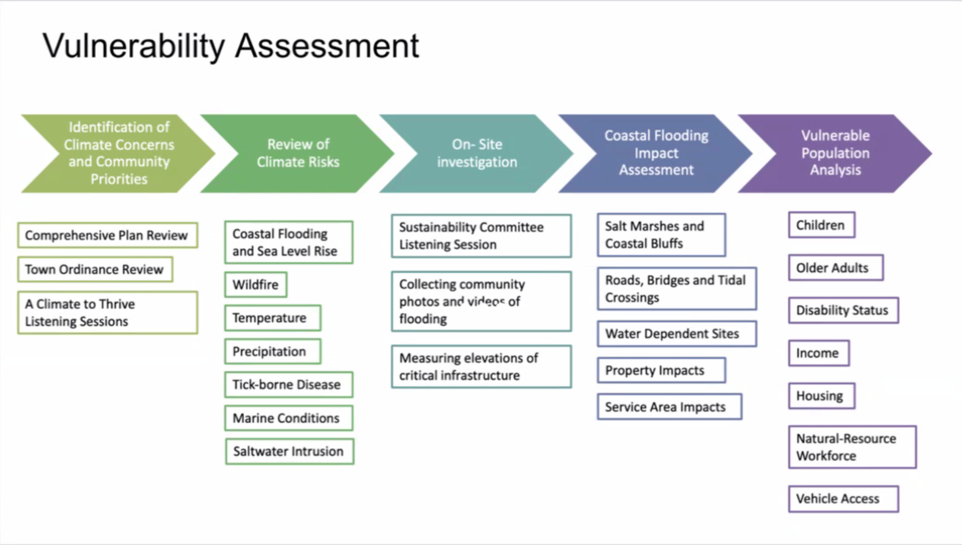
Though GMRI looked primarily at coastal flooding and sea rise, it also looked at other aspects of the climate and its potential changes including wildfire risk, precipitation levels, tick-borne diseases, marine conditions, and saltwater intrusion.
The scientists tried to center what it means to live in a community and how things like flooding impact how the people of the community can access services. If a road floods, they asked, how much longer would it take to get to a hospital. When they complete just one town’s assessment, they only know the added times from that town, rather than the additional times from roads for the entire island.
If someone lives in Tremont and the roads flood, they might know now that it will take them 10 additional minutes to get through Tremont toward the hospital. What they still don’t know is how much longer it will take to get to that hospital if roads are flooded in Southwest, Bar Harbor, Trenton, or Ellsworth during that same event. Or, if getting to a hospital will be possible during certain events. Or, just getting to a grocery store.
Just from living here, people of Hancock County know what roads are likely to flood. But the GMRI work has a lot of specificity of dates and timelines and scenarios, Blackman said, and a formal assessment also helps towns to get funds from outside sources to deal with these problems. This, she said, is what the region needs as a whole.
Originally, just six people attended the League of Towns meeting on Tuesday morning, April 23. The meeting was held in Tremont and on Zoom. Two of those people were speakers attending via Zoom. Three others, one a speaker, were held up in traffic. No members of the public attended.
The League of Towns is a collaborative unit of government serving Bar Harbor, Cranberry Isles, Ellsworth, Lamoine, Mount Desert, Southwest Harbor, Swans Island, Tremont, Trenton, and Acadia National Park. Typically, towns are represented by their managers at the meetings.
LINKS TO LEARN MORE
UPDATE: We’ve updated this story to include comments from Keith Higgins.
Donations for Bar Harbor’s Shore Path, which was severely impacted by the winter’s storms, can be made through GoFundMe at https://tinyurl.com/ycx9wdax or PayPal at https://tinyurl.com/57xu79u2.
Checks payable to “Shorepath Fund Bar Harbor VIA” can be mailed to 127 West St., in Bar Harbor or brought to Window Panes at 166 Main St. in Bar Harbor.
https://www.aclimatetothrive.org
Tremont Community Resilience Plan
https://gmri.org/stories/tremonts-quest-for-resilience-in-a-changing-climate
U.S. Climate Vulnerability Index
Mount Desert Island Historical Society’s Landscape of Change project
Tremont meetings:
May 1, 6:00 p.m.. Resilient Tremont – Community Supper
May 13, 8:00 a.m. Annual Town Election begins
May 14, 6:30 p.m. Annual Town Meeting
If you’d like to donate to help support us, you can, but no pressure! Just click here. And this post (like all of our posts) is free with no paywalls, so feel free to share it.
Bar Harbor Story is a mostly self-supported publication. To receive new posts and support our work, consider becoming a free or paid subscriber. Thanks for being here with us and caring about our community, too!
